
The City Nature Challenge (CNC) has evolved into one of the most significant citizen science events on the planet. What began in 2016 as a friendly rivalry between Los Angeles and San Francisco has transformed into a global movement involving hundreds of cities across dozens of countries.The 2026 edition promises to be the largest yet, with organizers expecting record-breaking participation from urban naturalists, students, families, and seasoned biodiversity enthusiasts alike.
The fundamental premise is elegantly simple: observe and document wild organisms in urban environments, upload your findings to the iNaturalist platform, and contribute to a growing database that scientists use to understand urban biodiversity.Yet beneath this simplicity lies a competitive framework that rewards strategy, preparation, and technical proficiency. The cities that climb the leaderboards are not necessarily those with the richest biodiversity they are the ones whose participants understand how to play the game effectively.
This comprehensive guide will walk you through every aspect of the City Nature Challenge 2026, from the essential dates and participation mechanics to advanced techniques that can dramatically increase your observation counts and identification success rates. Whether you are a first-time participant or a returning veteran seeking to refine your approach, the strategies outlined here will help you maximize your contribution and your city’s standing in this global celebration of urban nature.
Understanding the City Nature Challenge Framework
A. The Two-Phase Structure
The 2026 City Nature Challenge operates across two distinct periods, each with specific objectives and opportunities.
Phase One: Observation Window (April 24–27, 2026)
During these four days, participants venture into their local environments to photograph wild plants, animals, and fungi.The definition of “wild” is crucial here: organisms must not have been planted or placed there by humans, and they must not be under human care.This distinction excludes garden vegetables, household pets, and cultivated ornamental plants, while including spontaneous vegetation, native wildlife, and naturally occurring fungi.
Phase Two: Upload and Identification Period (April 28–May 10, 2026)
Following the observation window, participants have nearly two weeks to upload photographs, refine identifications, and engage with the iNaturalist community to verify observations.This period is equally important as the observation phase, since only properly identified observations reach “Research Grade” status and contribute fully to scientific datasets.
B. How the Competition Works
Cities compete across three primary metrics: total observations, total species recorded, and total participants.This tripartite scoring system creates strategic opportunities. A city with fewer participants but highly efficient observers can outperform a larger city with casual participation. Conversely, cities that mobilize broad community involvement can accumulate impressive observation counts through sheer volume.
The competitive dimension extends beyond city rivalries to include individual achievements. Top observers on iNaturalist can accumulate thousands of observations during the four-day window, demonstrating that dedication and technique matter enormously.The challenge also generates valuable scientific data regardless of competitive outcomes, with observations flowing into databases used for biodiversity research and conservation planning.
C. 2025 Participation Benchmarks
Understanding previous year’s performance provides useful context for setting goals. The 2025 City Nature Challenge recorded over 3.3 million observations across 102,945 participants, documenting more than 73,000 species globally.These figures represent both the scale of participation and the extraordinary biodiversity documentation possible when cities unite around a common purpose.
Pre-Challenge Preparation Strategies
D. Mastering iNaturalist Before the Challenge Begins
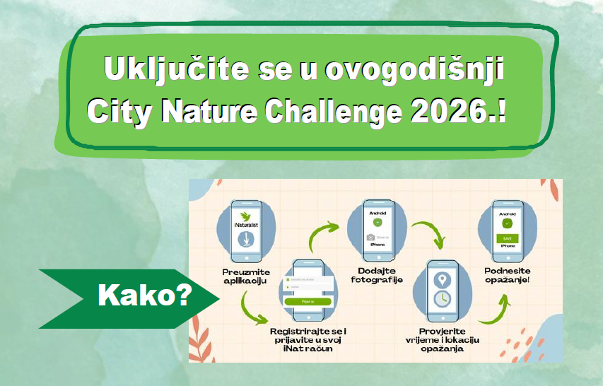
The most critical preparation step is achieving fluency with iNaturalist before April 24 arrives. Creating an account requires only minutes, but understanding the platform’s features, navigation, and upload processes can take considerably longer.
Essential iNaturalist skills to develop:
-
Observation creation workflow: Learn how to initiate observations, add photographs, input location data, and suggest species identifications.
-
Photo management: Understand how multiple images attach to single observations, and how to select the best representative photograph for each observation.
-
Location privacy settings: Configure geoprivacy for sensitive observations while ensuring open-access observations remain visible to researchers and other users.
-
Identification tools: Explore the “Suggest an Identification” feature, which uses image recognition to propose potential species based on visual characteristics.
-
Project participation: Join your city’s specific City Nature Challenge project to ensure observations are automatically added to the correct collection.
E. Optimizing Your Equipment Setup
While iNaturalist functions perfectly well with only a smartphone, participants seeking to maximize observation counts and identification accuracy benefit from strategic equipment choices.
Smartphone considerations:
-
Enable location services and ensure GPS accuracy is calibrated before heading into the field.
-
Clear sufficient storage space for photographs, as a productive observation session can generate hundreds of images.
-
Consider purchasing an external macro lens attachment for capturing small organisms like insects and lichens.
-
Test the iNaturalist app’s offline functionality, particularly if observing in areas with limited cellular coverage.
Supplementary gear:
-
A compact digital camera with macro capability can capture higher-quality images than most smartphones, improving identification success rates.
-
A notebook for recording location notes and habitat descriptions complements photographic documentation.
-
Portable power banks ensure devices remain functional during extended observation sessions.
F. Researching Your Local Biodiversity
Strategic participants prepare by learning what species occur in their region and where they are most likely to be found. This knowledge allows for targeted observation efforts rather than aimless wandering.
Research approaches:
-
Consult local field guides for plants, birds, insects, and fungi common to your area.
-
Explore iNaturalist’s existing observations in your city to identify biodiversity hotspots and productive locations.
-
Contact local naturalist groups, university biology departments, or parks departments for information about accessible natural areas.
-
Review the City Nature Challenge project page for your city to see which locations previous participants have found most productive.
Observation Techniques for Maximum Results
G. The Five-Second Rule for Quantity
During the observation window, speed matters. The most successful CNC participants develop efficient workflows that allow rapid observation and documentation without sacrificing data quality.
The “five-second rule” involves capturing a photograph immediately upon encountering an organism, then refining the shot if time permits. This approach ensures no observation opportunity is lost, even if the subject moves or environmental conditions change. The initial photograph may be imperfect, but it provides a baseline record that can be supplemented with additional images.
This technique proves particularly valuable when encountering fast-moving subjects like birds, butterflies, and mammals. Rather than attempting the perfect photograph and losing the subject entirely, capture the initial image and then improve it if possible.
H. Strategic Habitat Selection
Not all urban environments offer equal biodiversity documentation opportunities. Understanding habitat productivity allows strategic allocation of observation time.
High-productivity habitats:
-
Urban green spaces with native vegetation: Parks, nature reserves, and remnant natural areas support diverse communities of indigenous species.
-
Waterways and wetlands: Ponds, streams, rivers, and constructed wetlands attract aquatic organisms, water birds, and riparian species.
-
Transition zones: Areas where different habitat types meet such as the boundary between woodland and grassland often host species from both communities.
-
Disturbed ground: Vacant lots, roadside verges, and construction sites frequently support pioneer species and unexpected finds.
-
Vertical surfaces: Walls, fences, and tree trunks host lichens, mosses, and invertebrates often overlooked by casual observers.
Lower-productivity areas:
-
Monoculture lawns lacking flowering plants
-
Heavily manicured ornamental gardens
-
Areas dominated by invasive species with limited associated biodiversity
I. The Multiple Angle Approach
iNaturalist identifiers consistently emphasize that multiple photographs from different angles dramatically improve identification success rates.A single image may capture the organism’s general appearance but miss diagnostic features necessary for species-level identification.
Recommended photographic protocol:
-
First image: Overall habitus showing size, shape, and general appearance in context.
-
Second image: Close-up of diagnostic features for plants, this might include flowers, leaves, and seed pods; for insects, the face, wing venation, and leg structure.
-
Third image: Habitat context showing the surrounding environment and growth substrate.
-
Additional images: Detail shots of distinguishing characteristics, such as leaf undersides, stem cross-sections, or specialized structures.
This systematic approach transforms an ambiguous observation into a valuable scientific record that identifiers can confidently verify.
J. Timing Your Observation Sessions
Biodiversity activity varies dramatically throughout the day and under different weather conditions. Strategic timing can substantially increase observation counts.
Optimal observation times:
-
Early morning: Birds are most active and vocal, diurnal insects are warming up, and flowering plants are fresh.
-
Late afternoon to dusk: Nocturnal and crepuscular species begin activity, while diurnal organisms remain observable.
-
After rain: Many fungi, amphibians, and moisture-dependent invertebrates emerge following precipitation.
-
Warm, sunny days: Insects and reptiles are most active and visible during favorable weather.
Advanced iNaturalist Techniques

K. Understanding the Research Grade Pathway
Observations progress toward Research Grade status through community identification consensus. Understanding this process helps participants structure observations for maximum scientific value.
An observation typically requires at least two independent identifiers agreeing on a species-level identification to reach Research Grade. Observations with only one identifier agreement remain at “Needs ID” status, while those with conflicting identifications may be downgraded to higher taxonomic levels.
Strategies for achieving Research Grade:
-
Upload observations promptly during the observation window to maximize identifier engagement.
-
Tag knowledgeable identifiers who specialize in relevant taxa.
-
Provide detailed notes about habitat, location, and observed behaviors.
-
Respond to identifier questions and requests for additional photographs.
L. Avoiding the “Blind Agree” Trap
One of the most common mistakes in iNaturalist participation involves uncritically agreeing with identifications without independent verification.This behavior undermines data quality and can propagate misidentifications through the dataset.
The correct approach involves evaluating proposed identifications based on the photographic evidence, consulting additional resources when uncertain, and only confirming identifications when you genuinely believe they are correct. When you lack sufficient expertise to evaluate an identification, it is perfectly acceptable to leave the observation for more knowledgeable identifiers to review.
M. Managing Observation Licenses
iNaturalist allows users to specify licensing terms for their observations. While this may seem like a technical detail, license choices affect how observations can be used by researchers and whether they flow into downstream databases like iRecord and GiGL.
Consider dedicating observations to the public domain or using Creative Commons licenses that permit scientific and educational use. Restrictive licensing can prevent observations from contributing to biodiversity research and conservation planning.
Common Pitfalls to Avoid
N. Quantity Without Quality
The competitive nature of the City Nature Challenge can incentivize observation “spamming” uploading numerous low-quality observations of common species without meaningful documentation. While this may temporarily inflate observation counts, it often results in observations that never reach Research Grade and fail to contribute to scientific datasets.
A balanced approach prioritizes both volume and quality, recognizing that well-documented observations of diverse taxa provide more value than numerous unidentifiable images.
O. Neglecting Non-Charismatic Taxa
Many participants focus disproportionately on birds, mammals, and showy flowering plants while overlooking the vast majority of urban biodiversity. Insects, spiders, fungi, lichens, mosses, and other inconspicuous organisms collectively represent an enormous proportion of urban species richness.
Underappreciated taxa worth targeting:
-
Insects: Beetles, true bugs, flies, wasps, and moths
-
Arachnids: Spiders, harvestmen, and mites
-
Fungi: Mushrooms, bracket fungi, and lichens
-
Bryophytes: Mosses and liverworts
-
Mollusks: Snails and slugs
-
Annelids: Earthworms
P. Failing to Follow Up
The identification period from April 28 to May 10 represents a critical opportunity to refine observations and engage with the identifier community. Participants who upload observations but neglect this phase often see their records stagnate at “Needs ID” status.
Follow-up activities:
-
Review observations with suggested identifications and confirm or correct them
-
Respond to identifier comments and questions
-
Upload additional photographs if requested
-
Correct geographic coordinates or location information as needed
The Scientific and Conservation Impact
Q. Beyond the Leaderboard
While the competitive framework generates excitement and engagement, the City Nature Challenge’s ultimate value lies in its scientific contributions. The millions of observations generated annually provide researchers with unprecedented datasets documenting urban biodiversity patterns, species distributions, and phenological changes.
This data supports:
-
Conservation planning: Identifying important urban habitats and species of conservation concern
-
Invasive species monitoring: Detecting and tracking non-native species spread
-
Climate change research: Documenting shifts in species distributions and timing of life cycle events
-
Urban ecology studies: Understanding how biodiversity responds to urbanization gradients
-
Public health research: Connecting nature access with human well-being outcomes
R. Connecting Observations to Real Conservation
The observations you contribute during the City Nature Challenge do not disappear into a digital void. Records meeting appropriate criteria flow into national biodiversity databases, informing land management decisions, environmental impact assessments, and conservation strategies.
For example, observations of rare or protected species can trigger additional surveys and protective measures. Documentation of invasive species presence can prompt early intervention efforts. Accumulated data about pollinator distributions can inform habitat restoration priorities.
Conclusion: Your Role in Urban Biodiversity Documentation
The City Nature Challenge 2026 represents far more than a four-day competition. It is an opportunity to contribute meaningfully to scientific understanding of urban ecosystems, to develop your naturalist skills, and to connect with a global community united by curiosity about the natural world.
The strategies outlined in this guide from pre-event preparation through post-observation refinement will help you maximize both your personal achievement and your city’s competitive standing. But more importantly, they will help you become a more effective participant in the ongoing effort to document and understand the biodiversity that surrounds us, even in the most urbanized environments.
As you prepare for April 24–27, remember that every observation matters. The lichen on a city wall, the beetle in a park flowerbed, the bird singing from a rooftop each represents a data point in a vast scientific endeavor to understand how life persists and adapts in human-dominated landscapes. Your participation contributes to this understanding, one photograph at a time.